Image adriftneustadt24jpg
Image
Double Width
On
Caption
© Carla Anacker
Component

© Carla Anacker
An efficient way of getting lost in the city would be using the technology that is there "… to help people find their way." Google Maps claims that "The API returns the most efficient routes when calculating directions." * * Google Maps Platform
So, what if we play around with google directions and implement the new ones in an application for getting lost while walking?
1. Get the Google directions [text] Following is a common way you look for directions (get the routes) on Mapsof a dropped pin or a placespecifically walking routes And the way you can obtain it is by copying it to the clipboard. ** ** This method might not function on iOS devices!
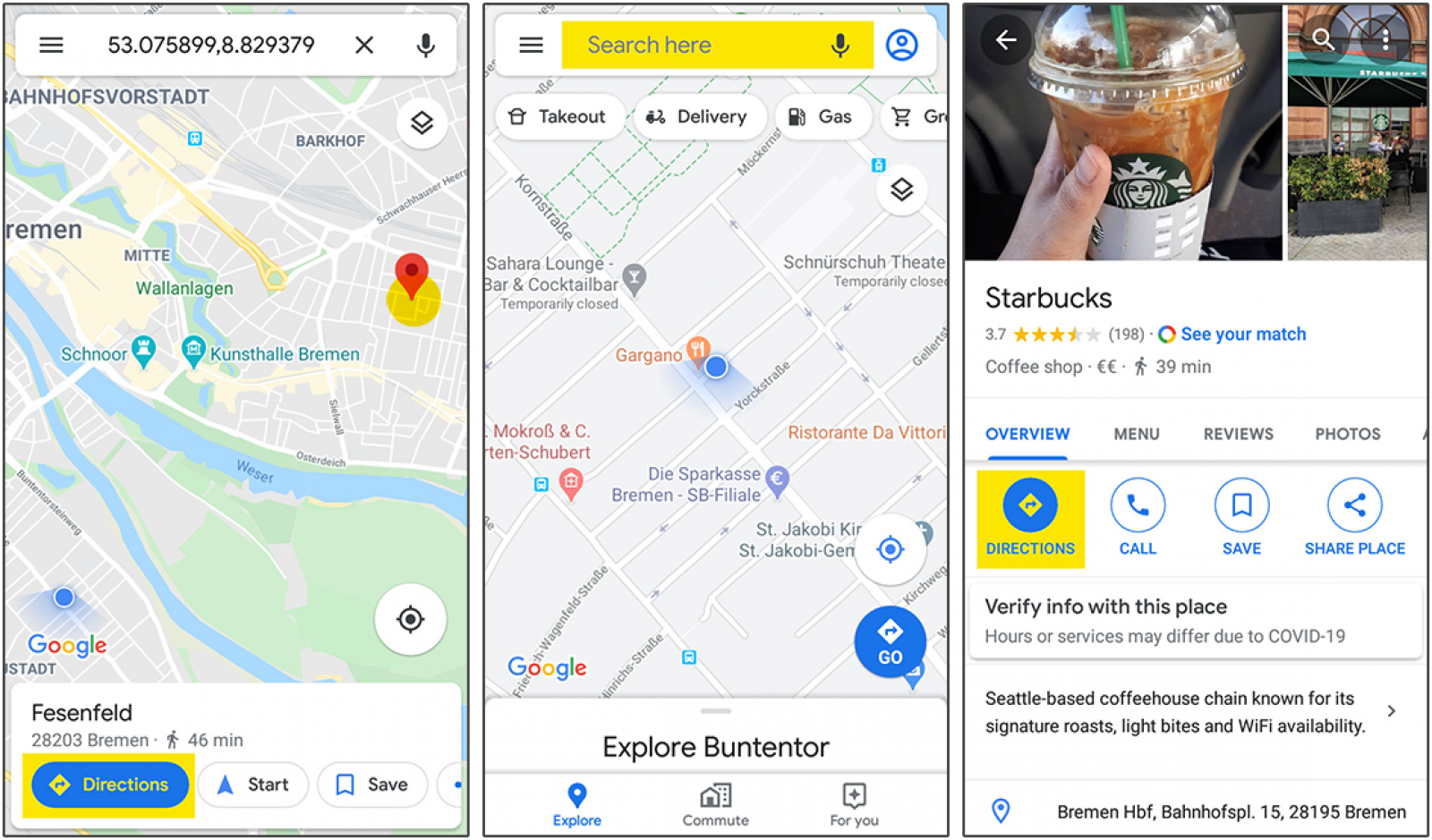
looking for directions of an intended destination

accessing the directions text by using share and copy to clipboard
SOME SHARED ROUTES/DIRECTIONS SAMPLES ↴
Shared routeFrom Hilde-Adolf-Park to Theater Bremen via Am Wall. 37 min (3.0 km) 1. Head southeast on Am Kaffee-Quartier toward Johann-Jacobs-Straße2. Turn right onto Lloydstraße3. Turn left onto Eduard-Schopf-Allee4. Continue onto Am Wall5. Slight left onto Altenwall/Am Wall6. Turn left onto Am Wall7. Continue onto Ostertorsteinweg8. Turn right toward Goethepl.9. Slight left onto Goethepl.10. Arrive at location: Theater BremenTo see this route visit /maps.app.goo.gl/gUuMXrKPNbgHii8D7
Shared routeFrom Gneisenaustraße to Starbucks via Wilhelm-Kaisen-Brücke. 1. Head northeast on Gneisenaustraße toward Hardenbergstraße2. Turn left onto Buntentorsteinweg3. Turn right onto Torn-Pad4. Turn left onto Weserdeich5. Continue onto Sankt-Pauli-Deich6. Turn right onto Wilhelm-Kaisen-Brücke7. Turn left toward Balgebrückstraße8. Turn right onto Balgebrückstraße9. Slight left onto Am Dom10. Turn right to stay on Am Dom11. Continue straight onto Domshof12. Turn left onto Schüsselkorb13. Continue onto Herdentorsteinweg14. Turn left onto Bahnhofstraße15. Turn right toward Bahnhofspl.16. Turn left onto Bahnhofspl.17. Arrive at location: StarbucksTo see this route visit /maps.app.goo.gl/qAzpKm37oqBo6Q6R9
Shared routeFrom Hollerallee to Bremen-Ost via Wachmannstraße. 37 min (3.0 km) 1. Head northwest on Hollerallee2. At the roundabout, take the 1st exit onto Wachmannstraße3. Exit the roundabout onto Wachmannstraße4. Turn right onto Schwachhauser Ring5. Turn left onto Wätjenstraße6. Turn right onto Friedhofstraße7. Turn left to stay on Friedhofstraße8. Slight right9. Turn left10. Turn right11. Turn left12. Turn right13. Turn left14. Turn left15. Arrive at location: Bremen-OstTo see this route visit /maps.app.goo.gl/iQPu24NUMHVMvE6y5
2. Interpret the steps After analyzing many directions texts, evaluate it using JavaScript string and array methods (e.g. split(), filter(), map()) to resolve/deconstruct the directions steps. We need to— get rid of empty lines— get rid of non-directional lines (keep the step lines only)— divide the step lines into separate words (in an array)— get rid of prepositions and names (proper nouns) in the step lines See the deconstructor() function in app.js here * (see the source code repository)https://github.com/farzadgo/adrift/blob/master/app/app.js
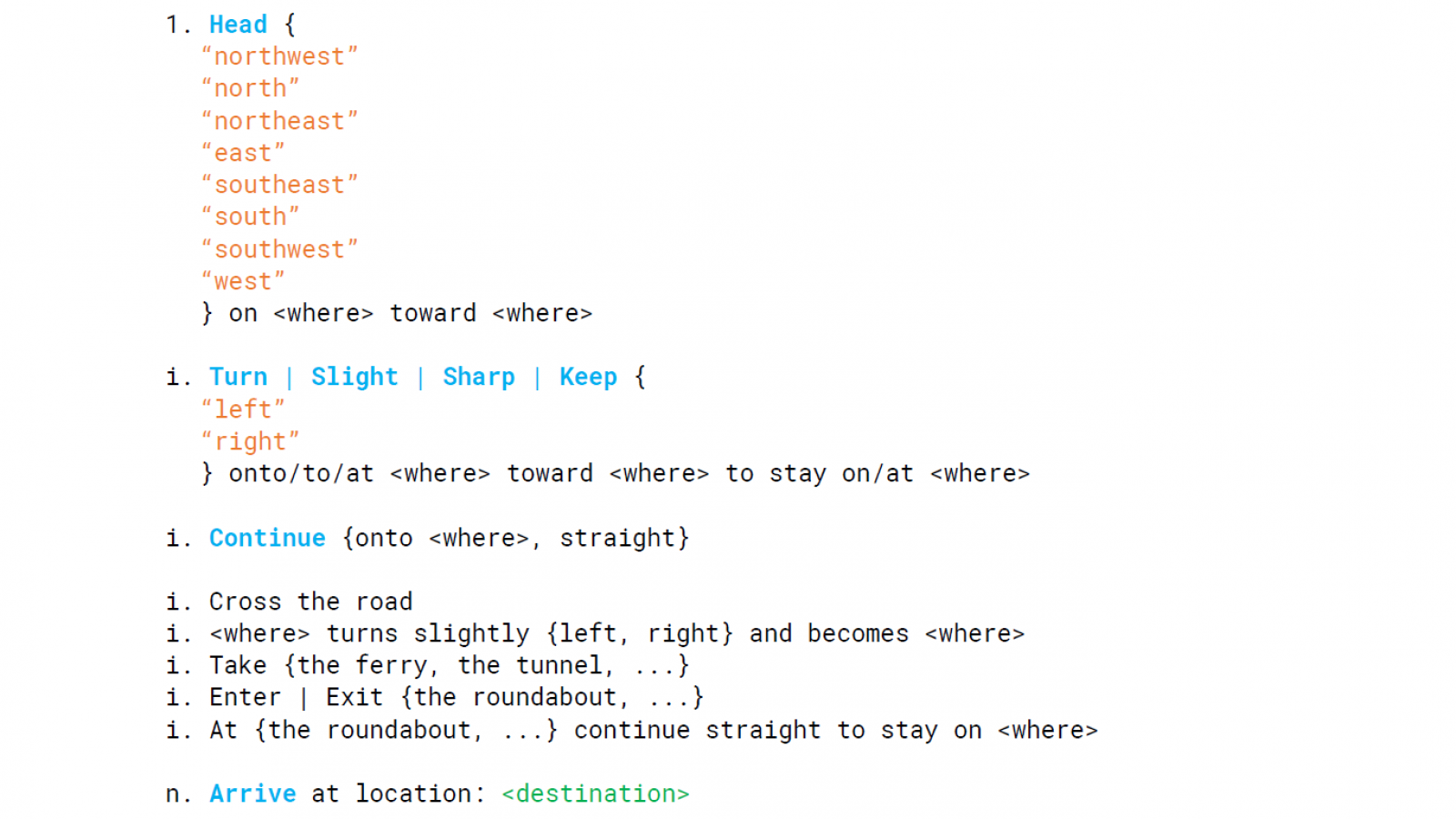
Analysis of different string cases used by Maps Directions API based on many cases

(empty and non-directional lines are gone) Step lines are split/divided into the arrays of their composing words.
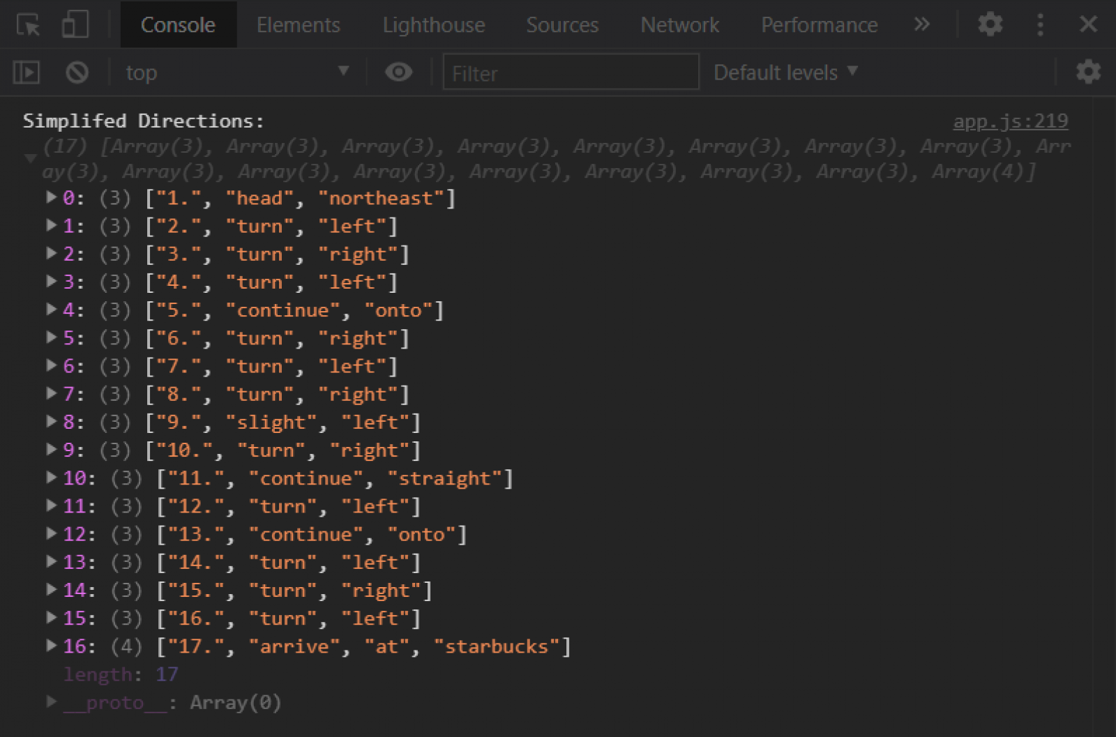
Steps are simplified by getting rid of prepositions and names.
3. get the new steps The rules for reconstructinghead southeast ⟶ head northwest ...turn left ⟶ turn rightturn right ⟶ turn left[odd step] ⟶ 2nd / 4th left/right[even step] ⟶ 1st / 3rd / 5th left/rightcontinue ⟶ cross the street[other arguments] ⟶ turn any directionarrive ⟶ enjoy getting lost
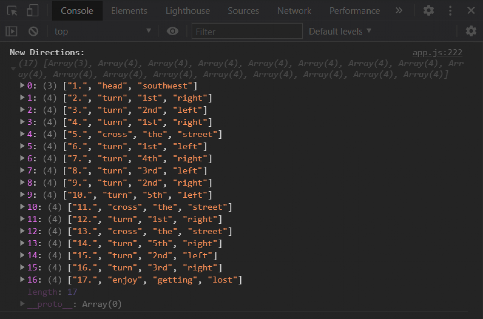
The [arrays of] new steps

© Carla Anacker
Another factor in an efficient getting lost, would be decreasing the interactions with the device and increasing the environmental entanglement. "… let themselves be drawn by the attractions of the terrain and the encounters they find there." * * Guy Debord - Theory of the Dérive
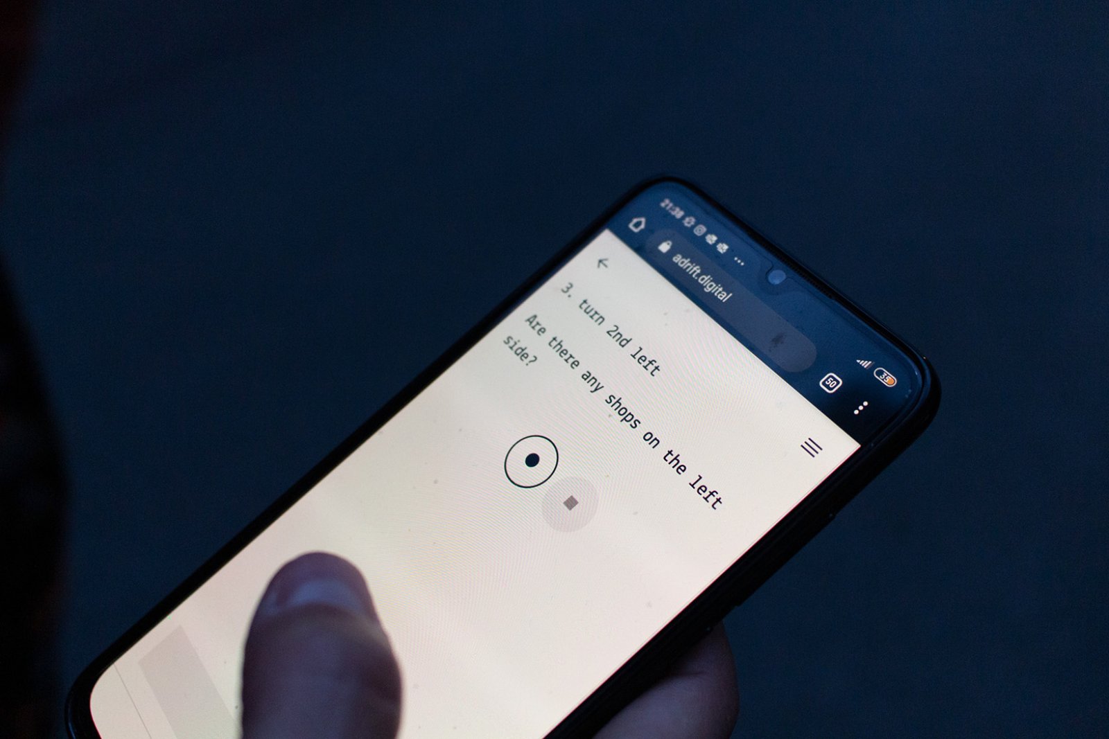
4. Get immediacy to each step In order to get lost, we need to be playful and imaginary about the immediate geographical environment. So let's assign various questions to each step from the pool of psychogeographical questions. questions such as— What do you see on the left side?— Are there any surveillance cameras around?— Are there any shops on the right side?— How old could the building/space on the right be?— What is the material under your feet?— . . . (think about more) In other words, the objective here is to get involved in conversations about the situations in varied ambiances through answering the questions about what we see, feel, think, imagine, etc.

Questions assigned to each step

© Carla Anacker
Now that we eliminated the map-reading process through our anti-Google Maps recipe, we might like to enact the map-making process during our journey. "mapping unfolds potential; it re-makes territory over and over again, each time with new and diverse consequences." * * James Corner - The agency of Mapping
5. Audio record the steps Although it is not clear if the product of a mapping process should mainly be consumed visually or not, the audio recordings of constructed situations (conversations) fit into the notion of [performative] mapping. This is especially due to the participatory aspects of the urban walks, or after all, the drifts.
— Google Maps Platform, Directions API, https://developers.google.com/maps/documentation/directions/overview— Adrift, (2020), GitHub repository, https://github.com/farzadgo/adrift/— Debord, G. (November 1956) Theory of the Dérive, Translated by Ken Knabb, https://www.cddc.vt.edu/sionline/si/theory.html— Corner, J. (1999) The agency of Mapping: Speculation, Critique and Invention, Chapter 1.12 in The Map Reader: Theories of Mapping Practice and Cartographic Representation (eds. M. Dodge, R. Kitchin and C. Perkins), John Wiley & Sons, Ltd., New York, pp. 89-101